Drone Technology: The New Frontier of Innovation
|
Getting your Trinity Audio player ready...
|
EXPLAINER
What is Drone Technology (UAV)?
Unmanned Aerial Vehicles (UAVs), commonly known as drones, are aircraft that fly without a human pilot onboard. They are either controlled remotely by a pilot on the ground or fly autonomously using pre-programmed software and onboard sensors like GPS, LIDAR, and IMUs. In the global context, drone technology has evolved from military surveillance tools into versatile instruments for commercial, agricultural, and recreational use.
To function effectively, a UAV typically integrates several high-tech modules:
- GNSS (GPS/GLONASS): Allows the drone to know its precise location, perform ‘Return to Home’ functions, and hover steadily in one spot.
- IMU (Inertial Measurement Unit): Detects changes in orientation and velocity.
- Data Link: A radio frequency (RF) link that transmits commands from the operator and sends telemetry (speed, altitude, battery life) and live video back to the ground.
- Payload: This is the equipment the drone carries to perform a specific task, such as 4K cameras, LiDAR sensors for 3D mapping, or thermal imaging for search and rescue.
How Drones Fly?
Drones rely on a combination of hardware and sophisticated software to maintain stability and navigate.
- Propulsion System: Most consumer drones are multirotors like quadcopters. They use motors and propellers to create lift. By varying the speed of individual motors, the drone can pitch- tilt forward/back, roll – tilt side-to-side, or yaw- rotate.
- Flight Controller: This is the brain of the drone. It processes data from sensors like gyroscopes, accelerometers, and GPS to ensure the craft remains level and follows the pilot’s commands.
- Power Source: Most UAVs use Lithium-Polymer (LiPo) batteries for their high energy density, though larger industrial drones may use fuel cells or hybrid engines for longer endurance.
How do drones stay stable in the air?
Drones utilize a complex interplay of Inertial Measurement Units (IMUs), which include gyroscopes and accelerometers. These sensors detect tiny shifts in orientation and speed, sending data to the flight controller hundreds of times per second. The controller then adjusts the RPM of individual motors to counteract wind or tilt, ensuring the platform remains perfectly level.
What is LiDAR, and why is it expensive?
LiDAR (Light Detection and Ranging) uses laser pulses to measure distances. It creates a point cloud that can see through dense forest canopies to map the ground below. It is expensive because of the precision required in the laser emitters and the high-speed processing power needed to sync the data with the drone’s GPS position in real-time.
What are the limitations of drone batteries?
Most commercial drones use Lithium Polymer (LiPo) batteries, which offer high power-to-weight ratios but typically only provide 20-40 minutes of flight time. This range anxiety is a global bottleneck. Researchers are currently exploring Hydrogen Fuel Cells and solid-state batteries to push flight times beyond the two-hour mark.
What is Edge Computing in drones?
Normally, a drone captures data and it is processed later on a computer. With Edge Computing, the drone processes the data while flying. For example, a security drone can use AI to identify a person of interest or a license plate instantly without needing to send the huge video file back to a central server first.
How do drones avoid obstacles autonomously?
Advanced drones use computer vision and ultrasonic sensors. By using stereo vision- two cameras acting like human eyes, the drone’s onboard processor calculates the depth and distance of objects. This allows the drone to re-route its path in real-time if a tree or a person moves into its trajectory.
Why is First Person View (FPV) popular?
FPV involves the pilot wearing goggles that stream a live video feed from the drone’s perspective. While popular in drone racing, it has serious commercial applications in cine whoops -smooth indoor filming and search and rescue, where a pilot needs to navigate tight, complex spaces like collapsed buildings or caves.
How are drones classified in India?
According to the Drone Rules 2021, India classifies drones based on their Maximum All-Up Weight (including payload). The categories are: Nano (up to 250g), Micro (250g to 2kg), Small (2kg to 25kg), Medium (25kg to 150kg), and Large (greater than 150kg). This classification determines the level of regulatory compliance, such as the need for a Pilot License or Unique Identification Number (UIN).
What is the difference between ‘Line of Sight’ (VLOS) and ‘Beyond Visual Line of Sight’ (BVLOS)?
Visual Line of Sight (VLOS) requires the pilot to maintain direct eye contact with the drone at all times. Beyond Visual Line of Sight (BVLOS) allows the drone to fly miles away, controlled via telemetry or autonomous programming. While VLOS is standard for hobbyists, the global push for BVLOS is essential for delivery services and long-range infrastructure inspections.
What is the Digital Sky Platform?
The Digital Sky Platform is India’s secure, cloud-based framework for managing Unmanned Aircraft Systems (UAS). Developed by the Directorate General of Civil Aviation (DGCA), it serves as a digital gateway for drone registration and flight authorizations.
It implements the ‘No Permission, No Takeoff’ (NPNT) policy, requiring pilots to obtain an automated permission artifact before a drone can arm its motors. By integrating flight logs, operator permits, and real-time tracking, Digital Sky ensures airspace security while streamlining commercial operations. It categorizes the national airspace into Green, Yellow, and Red zones, providing a transparent regulatory environment for the growing drone ecosystem.
What are ‘Green Zones’ in the Indian airspace map?
Green zones are designated airspaces where no flight permission is required for drones up to 500kg. These typically extend up to 400 feet (120m) vertically. Flying in these areas is the most friction-less way for startups and hobbyists to operate, provided they are registered and stay away from airport perimeters.
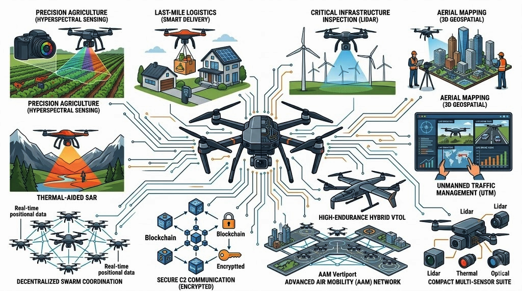
What is ‘Swarm Technology’ in a military context?
Swarm technology involves operating dozens or hundreds of drones as a single, coordinated unit using Artificial Intelligence. Rather than a pilot controlling one drone, a single operator manages the hive. Globally, this is a major defence trend, as swarms can overwhelm enemy radar and air defences through sheer numbers and decentralized decision-making.
How does India’s drone policy compare to the FAA (USA) or EASA (Europe)?
India’s drone policy is distinguished by its Green Zone liberalization and strict indigenization. Unlike the FAA (USA) or EASA (Europe), which prioritize risk-based airspace integration, India’s Drone Rules 2021 focus on creating a domestic manufacturing hub by banning most foreign drone imports.
While the FAA utilizes Remote ID for tracking and EASA relies on rigid CE hardware classifications, India employs the DigitalSky Platform with a No Permission, No Takeoff (NPNT) hardware mandate. This centralized digital approach offers more automated, friction-free flying in designated Green Zones compared to the more complex authorization layers found in Western frameworks.
What are the privacy concerns regarding drone technology?
The ability of drones to carry high-definition cameras into private spaces raises significant privacy and surveillance issues. Globally, laws are being drafted to prevent unwarranted surveillance. In India, the Drone Rules emphasize that drone operations must not violate a citizen’s right to privacy, and unauthorized capturing of images over private property can lead to legal action under existing privacy laws.
What is the environmental impact of drone technology?
Drones are generally more green than the alternatives. Replacing a 2-ton delivery van with a 5kg electric drone for the last mile significantly reduces carbon emissions. Additionally, in agriculture, the precise application of chemicals via drones prevents over-spraying, which protects local groundwater from excessive pesticide runoff.
How is drone technology revolutionizing Indian agriculture?
Drones are primarily used for precision spraying and crop health monitoring. Using multispectral sensors, drones can identify patches of crops that are stressed or diseased before the human eye can see them. In India, the government’s Kisan Drone initiative promotes using drones to automate pesticide spraying, reducing chemical exposure for farmers and saving water.
How are drones used in the power and energy sector?
Inspecting high-voltage power lines or wind turbine blades is dangerous for humans. Drones equipped with thermal cameras can detect hot spots – indicators of electrical failure, from a safe distance. Globally, this reduces downtime and maintenance costs by nearly 30-50% compared to traditional helicopter or manual climbing inspections.
What is the ‘SVAMITVA’ scheme?
The SVAMITVA scheme (Survey of Villages Abadi and Mapping with Improvised Technology in Village Areas) is a Central Sector initiative aimed at establishing clear property ownership in rural India. Launched by the Ministry of Panchayati Raj, it utilizes drone technology to map inhabited land parcels (Abadi) with high precision. By providing Property Cards to rural owners, the scheme creates accurate land records, reduces property disputes, and enables villagers to use their property as financial assets for bank loans.
What is Anti-Drone technology?
As drones become more accessible, they can be used for rogue activities like smuggling or spying. Anti-drone systems use RF jamming to break the link between the pilot and the drone, or spoofing to take control of the drone’s GPS. Some advanced systems even use high-energy lasers or net-guns to physically take them down.
Will drones replace satellites for mapping?
Drones won’t replace satellites, but they complement them. Satellites provide global coverage, but drones provide sub-centimeter resolution and can fly under cloud cover. For a construction site or a small farm, a drone is much more cost-effective and provides far more detail than any commercial satellite imagery currently available.
What are Vertiports?
As we move toward Urban Air Mobility (UAM) think flying taxis we need dedicated infrastructure. Vertiports are specialized landing pads equipped with high-speed charging and passenger terminals. Global cities like Paris and Dubai are already designing these to integrate manned drones into their public transport networks.
How is AI changing drone photography?
AI now allows for Auto-Framing and Subject Tracking. Instead of a pilot manually tilting the camera, the AI recognizes a subject (like a car or a runner) and keeps them perfectly centered regardless of how the drone moves. This has democratized high-end cinematography, allowing a single operator to get shots that previously required a full crew.